Conversion between Latitude/Longitude and
Montana State Plane Coordinates
This page contains tools for converting between Montana
State Plane Coordinates, in meters, and Latitude/Longitude.
All conversions are done on the North American Datum of 1983.
- Web-based form for converting a
Latitude and Longitude to a State Plane Coordinate.
- Web-based form for converting a
State Plane Coordinate to Latitude and Longitude.
-
Download a Windows 95/98/NT program for converting back
and forth between Latitude and Longitude and State Plane.
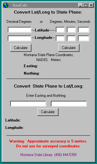
The interface for the program is shown
here. The program operates only in interactive mode
and cannot at this time process batches of coordinates
from files.
The formulae these programs are based on appear in "Map Projections, A
Working Manual" by John P. Snyder, U.S. Geological Survey
Professional Paper 1395, 1987, on pages 107-109 and 295-298.
The programs that perform these calculations may be viewed as Perl code:
or as Active Server Page/VB Script code (in some browsers you may need
to right-click on the page and say View Source):
Here is a PowerPoint presentation on map projections and coordinate systems. This presentation has substantial information in its Notes -- please right-click on the link and download the file, then view it with PowerPoint in Normal mode, so that you can read the Notes.
|